|
11 May 2009
Humanitarian Resource Institute
IDIN:
Community
& Family Preparedness Network
Subject: 2009 National Hurricane Preparedness Initiative
Call for FEMA Review/Funding for Coastal Communities
- 2009 Hurricane Preparedness Initiative
Compiled by Stephen M. Apatow, Director of Research and Development,
Humanitarian Resource Institute
Introduction
The focus is catastrophic damage to direct waterfront homes and coastal communities
(Hurricanes Andrew and Katrina:
$100 Billion estimated property losses), specifically loopholes that allow
avoidance of construction standards required for a coastal high hazard
areas. Responsibility for adherence to construction standards
outlined by the FEMA National
Flood Insurance Program and International Building Code has been entrusted
to municipalities and states. At the present time, the Federal Emergency
Management Agency (FEMA) who administers the National Flood Insurance Program
(NFIP), has no enforcement capacity to address violations within states.
Risk Analysis
My personal involvement with national community and family preparedness
campaigns with FEMA range from national county level education programs
and material development for El Nino to leading/participation in preparedness
education programs for state emergency managers at the Mt. Weather Emergency
Operations Center. I currently administer the Humanitarian Resource
Institute Community
and Family Preparedness Network, International Disaster
Information Network and Global Preparedness and Response Network.
In 2007, I had an opportunity to become engaged with discussions
associated with coastal erosion and environmental challenges in Milford,
Connecticut. Of significant concern, was destruction of the floodplain
and two direct waterfront projects, that were being build to standards for
a coastal flood hazard area, but not a coastal high hazard area.
|
|
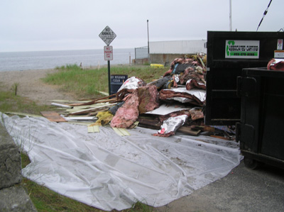
Demolition: Asbestos hazmat containment
in floodplain, critical wildlife habitats, a reservoir for sand supply,
a buffer for coastal flooding and erosion intact.-- Photo: Milford, Connecticut
Coastal Protection Initiative, September 2007.
|
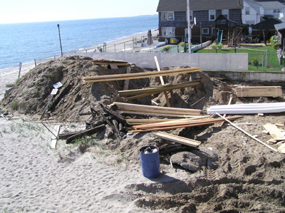
Floodplain reconstruction. -- Photo:
Milford, Connecticut Coastal Protection Initiative,
September 2007.
|

|
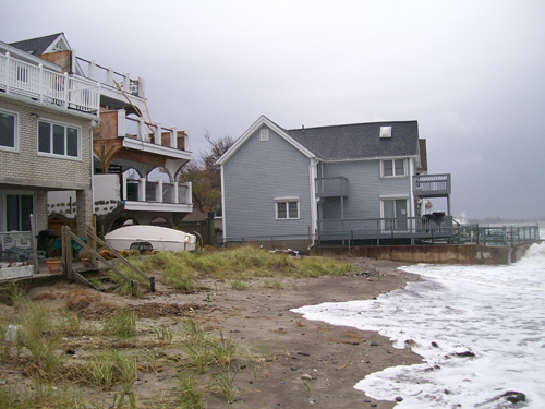
This photo illustrates the high water
line moving into the floodplain where seagrass was removed and in extreme
high tides encompasses a flow through to the street (Broadway). One
major storm can accommodate a new waterway to the street.
The concern for this home, in a direct flood plain, was construction
standards for a non-coastal high hazard area.
28 October 2008
|
|
|
|
|
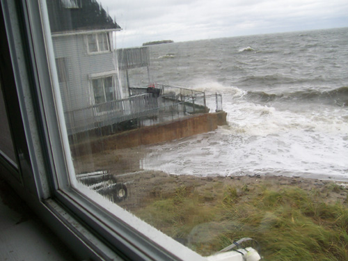
Coastal erosion has brought the high water line
up to the porches of homes constructed on pilings, some with basements
(as the waterline has reached these porches (no breech) saturation accommodated
flooding). -- 28 October 2008
|
In the event of potential erosion, and saturation
challenges, concerns for 4 story homes not constructed on pilings, encompasses
compromise of the substructures. -- 28 October 2008
|
Efforts to address
these public safety concerns and code violations, were ignored by local and
state authorities. Over the course of a two year period, I made a request
to the Governor's office for assistance in this matter [1, 2, 3, 4], that
led to her referral of the problem to the DEP Commissioner Gina McCarthy.
[5]
The loophole encompassed use of the FEMA flood maps, to make a determination
that direct waterfront construction could be built to the lower standard of
a flood hazard area instead of a coastal high hazard area. This paradoxical
perspective was in direct contrast to my view that every direct waterfront
property existed in a coastal high hazard area (especially since previous
hurricanes, including 1938, impacted the area with 10-20 ft tidal surges,
wave impact and high winds).[6] In support of my view was the 2003
International Residential Code: Portion of the 2005 State Building Code,
State of Connecticut [7]:
R323.3 Coastal high-hazard
areas (including V Zones). Areas that have been determined to be
subject to wave heights in excess of 3 feet (914mm) or subject to high
velocity wave action or wave induced erosion shall be designated as coastal
high-hazard areas. All buildings and structures erected in coastal
high-hazard areas shall be designed and constructed in accordance with R323.3.1
through R323.3.6.
In response to these concerns, the State of Connecticut, EPA Environmental
Analysis Division of the Office of Long Island Sound Programs conducted a
site plan review of one of the construction sites and provided specific
guidance for the municipal planning and zoning and building departments
[8]. The review stated:
Evidence of a wrack line left by high tides was slightly waterward
of the southern limit of the beach grass, defining the State’s regulatory
jurisdiction. Additionally, the parcel lies within a Zone AE (Elevation
11’ NGVD) and a Zone VE (Elevation 15’ NGVD) coastal flood hazard areas as
shown on FEMA’s Flood Insurance Rate Map (FIRM) for the City of Milford,
Panel 6 0f 6, or Community Panel 090082 0006 G (revised November 6, 1996).
A review of the FIRM shows that the Zone VE line is located approximately
140’ from Broadway Avenue and 120’ landward of the shoreline (see attached
map and photo). If the VE Zone were to be transposed from the FIRM
based on the location of the shoreline on the map, it would be placed near
the landward end of the proposed dwelling, indicating that the dwelling
must be constructed to VE Zone standards (i.e., elevated on piles above 15’
NGDV) . This information indicates that significant erosion of
the beach has taken place since the FIRM was revised in 1996, that the FIRM
contains a significant error, or both. However, the design of the development
should reflect the actual hazards from storm waves and surge versus what
is implied by the FIRM. pg 1-2
Pg. 4-5: Point 4
The site plan does not include all coastal flood hazard limits as shown
on the FIRM. The Zone VE, which is a more hazardous area, should be
accurately shown on the plans. Before the Board can make any decision
on this application, an accurate Zone VE line must be depicted on the site
plan. Because the Zone VE limit on a beach include the anticipated erosion
of beach and dune system and are not simply determined by elevation, we
believe that an accurate boundary may show that the proposal must be constructed
to Zone VE standards.
Summary and Recommendations
The proposal is inconsistent with CCMA beaches and dunes policies
and does not minimize hazards to life and property. We are concerned that the proposal
may be located in or very close to the Zone VE coastal flood hazard area.
This is of particular concern because the beach could experience severe
erosion in a major coastal storm, thus resulting in larger waves hitting the
dwelling than the design anticipates. The erosion could then undermine
the dwellings foundation. Because the CCMA does
not allow shoreline flood & erosion control structures to be used to
protect inhabited structures built after 1980, it is critical for the board
to approve waterfront projects that are designed and located such that no
future structural protection would be necessary.
Despite this guidance. municipal and state administrative offices ignored
these directives and construction continued for approximately 2 years. Efforts
to address these public safety concerns expanded with with requests to the
regional FEMA offices and then federal agencies that included the FEMA Mitigation
Directorate, National Oceanic and Atmospheric Administration (NOAA)
and National Weather Service. All this simply to help the municipality
and state understand that direct waterfront properties existed in a coastal
high hazard area.
This exercise revealed that FEMA had no capacity to enforce the National
Flood Insurance Protection Program/International Building Code construction
requirements for coastal high hazard areas, and that the responsibility was
completely placed in the hands of the municipal and state authorities.
The only pathway for resolution of these public safety issues
by citizens was stated to be litigation or appeals to local elected officials.
Today, local citizens in this community are (1) holding all parties responsible
for the public safety threats presented by all non-conforming structures,
(2) compensation for associated devaluation of adjacent properties, and (3)
demanding immediate action for construction modifications to FEMA NFIP/IBC
and state building code standards for coastal high hazard areas (height
modifications and elevation on piles above 15’ NGDV, breakaway walls, etc.,
etc).
|
|
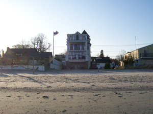
Ref property 1: Post removal of seagrass and
natural protective barrier, built in the direct flood flow through
to the street.
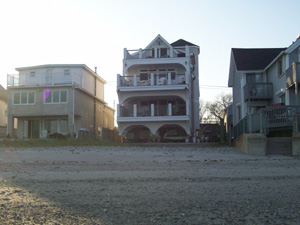
|
Ref property 2: 4 story construction
project built to a construction standard for coastal flood hazard area,
vs. a coastal high hazard area.
|
Call for FEMA Review
of Direct Waterfront Construction in all U.S. Coastal Communities
This public safety construction challenge has revealed that
FEMA NFIP violations are a problem in all coastal states.
1. FEMA examination of direct waterfront construction in U.S. coastal
cities, to provide guidance pertaining to non-conforming structures in
conjunction with the 2009
National Hurricane Preparedness Initiative coordinated by Humanitarian
Resource Institute.
2. Funding to support modification of non-conforming structures
permitted by municipalities, state and federal programs
References:
[1] Coastal Erosion Discussion: 31 October 2008: Coastal
High Hazard Areas: Precedent for the threat to direct waterfront properties
by previous storms (Hurricanes) that have encompassed surges of 15-20
ft + and property damage projections (Cat 1-4) outlined by the University
of Connecticut.
[2] NOAA Response - 3 September 2008: Federal Emergency
Management Agency (FEMA), National Oceanic and Atmospheric Administration
(NOAA), National Weather Service (NWS) in a discussion that impacts every
coastal community in the United States.
[3] State DEP Response - 6 August 2008:
Connecticut Post facilitates expansion of national community and family
preparedness initiatives to strengthen, secure and protect coastal communities.
[4] Milford, Connecticut Coastal Protection Initiative:
Construction in coastal high hazard areas, removal of seagrass, a
reservoir for sand supply, a buffer for coastal flooding and erosion
concerns citizens. September 2007.
[5] Obama Nominates Gina McCarthy for EPA Air Office: Center
for Environment, Commerce & Energy: 20 March 2009.
[6] Hurricane of 1938 with landfall in New Haven, Connecticut:
WINDS: 115 -mph (moving at 50-mph), PRESSURE: 27.94 inches/946
mb, STORM - SURGE: 12 - 16 feet above Mean Tide. In terms of fatalities
and property damage - the 1938 hurricane is still one of the worst disasters
in North American history. In a matter of hours, 688 people were killed,
4500 were injured, and more than 75,000 buildings were damaged or destroyed.
The states of New York, Connecticut, and Rhode Island, suffered their
worst natural disaster in recorded history. The tidal wave like storm-surge
that hit Long Island and Rhode Island was so severe - that earthquake
instruments 3,000-miles away recorded it on seismographs.
[7] 2003 International Residential Code: Portion of the 2005
State Building Code, State of Connecticut: R323.3 Coastal high-hazard
areas (including V Zones). Areas that have been determined to be
subject to wave heights in excess of 3 feet (914mm) or subject to high
velocity wave action or wave induced erosion shall be designated as coastal
high-hazard areas. All buildings and structures erected in coastal high-hazard
areas shall be designed and constructed in accordance with R323.3.1 through
R323.3.6.
[8] Coastal Site Plan Review: State of Connecticut, EPA
Environmental Analysis Division of the Office of Long Island Sound Programs,
1 October 2007.
These challenges have prompted our request for
who were responsible for enforcement of the FEMA NFIP/IBC and state building
code requirements.
|