| .
-------- Original Message --------
Subject: Coastal Erosion
Discussion: 31 October 2008
Date: Fri, 31 Oct 2008 10:45:13
-0800
From: Stephen M. Apatow,
Humanitarian Resource Institute
To: John Gaucher, State of
Connectcut, Department of Environmental Protection
31 October 2008
Humanitarian Resource Institute
Legal Resource and Assistance Center
Connecticut Coastal Protection Initiative
Dear John:
I just wanted to take this opportunity to expand our discussion regarding
coastal erosion issues in Milford, Connecticut. As you know, we have
been engaged in numerous discussions associated with construction of waterfront
homes in coastal high hazard areas.
A key question on the table is: In the event of significant erosion,
that compromises a substructure (resulting in sinkage/potential collapse)
of a direct waterfront 4 story building (constructed to a non-coastal
high hazard standard), what guidance would the municipality and state provide
to prevent collapse?
Note: I have shared that as waterlevels have reached the decks of direct
waterfront homes with basements (Approx. 7 ft below ground), saturation
of the sand has accommodated flooding (as per the importance of soil tests).
Our precedent for the threat to direct waterfront properties are previous
storms (Hurricanes) that have encompassed surges of 15-20 ft + and property
damage projections (Cat 1-4) outlined by the University of Connecticut:
- The Effects of Elevation Datasets on Coastal Flood Mapping
(PDF): Detailed analysis of the town of Milford, Connecticut.
Mark Hoover & Nick McNamara & Jason Miller, Center for Land
use Education And Research (CLEAR), University of Connecticut NASA DEVELOP
Project 2006, Department of Natural Resources Management and Engineering.
Precedent Storms: 1938: The hurricane produced storm tides of
14 to 18 feet (5 m) across most of the Long Island and Connecticut
coast, with 18 to 25-foot (8 m) tides from New London to Cape Cod...
To this day, the 1938 hurricane holds the record for the worst natural
disaster in Connecticut's 350-year history... Along the Stonington
shorefront, buildings were swept off their foundations and found two miles
(3 km) inland. Rescuers later searching for survivors in the homes in
Mystic found live fish and crabs in kitchen drawers and cabinets. --
New England Hurricane of 1938, Wickpedia.
As per our discussions regarding in accurate maps reflecting erosion and
the high tide line, I would like to direct your attention to the following
digital photos (taken approx. 2 hours after high tide on 28 October
2008). This is a mild storm, without coastal flood warnings for the
area.
|
|
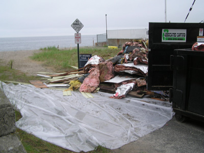
Demolition: Asbestos hazmat containment in floodplain,
critical wildlife habitats, a reservoir for sand supply, a buffer for
coastal flooding and erosion intact.-- Photo: Milford, Connecticut Coastal Protection Initiative, September
2007.
|
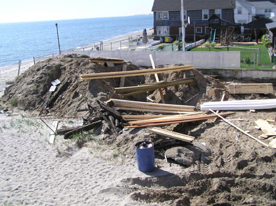
Floodplain reconstruction. -- Photo:
Milford, Connecticut Coastal Protection Initiative, September
2007.
|

|
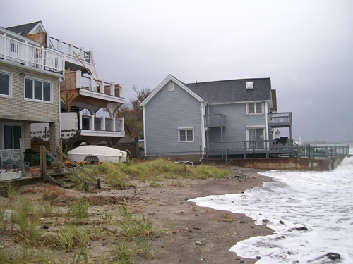
This photo illustrates the high water line moving
into the floodplain where seagrass was removed and in extreme high tides
encompasses a flow through to the street (Broadway). One major storm
can accommodate a new waterway to the street.
The concern for this home, in a direct flood plain, was construction standards
for a non-coastal high hazard area.
28 October 2008
|
|
|
|
|
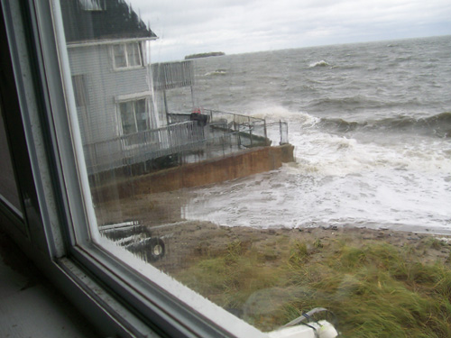
Coastal erosion has brought the high water line up to the porches of homes
constructed on pilings, some with basements. As the waterline has reached
these porches (no breech) saturation has accommodated flooding. --
28 October 2008
|
In the event of potential erosion, and saturation challenges, concerns
for 4 story homes not constructed on pilings, encompasses compromise of the
substructures. -- 28 October 2008
|
It is common sense, that all construction reflects the challenge presented
by previous historical weather events that have impacted the area. In
regards to construction projects that are non conforming, in the context
of state building code guidelines for coastal high hazard areas, modifications
are required to bring these structures to a conforming standard. As
per our previous discussions, this is a public safety coastal mitigation
priority.
It is our hope that modifications to non-conforming homes could be completed
pre-crisis and would appreciate the guidance of the Department of
Environmental Protection and State Building Inspector (Office of Public
Safety).

|
Storm surge is simply water
that is pushed toward the shore by the force of the winds swirling around
the storm. This advancing surge combines with the normal tides to create
the hurricane storm tide, which can increase the mean water level 15
feet or more. In addition, wind driven waves are superimposed on the storm
tide. -- Storm Surge: National Hurricane Center, NOAA.
|
I am looking forward to review of the new FEMA coastal maps as a reference
point for coastal preparedness initiatives. Please direct any additional
information to my attention.
Thank you for your help and guidance in this discussion.
S.M.Apatow
|
|