| .
|
Please Note: Regarding contact information for local elected officials via the website Congress.org,
many cities have limited direct email access. FYI, our local media
networks have access to that contact information and can facilitate forwarding
of important information, visit: Media Awareness Project: Media Email Directory.
September 2007
Milford, Connecticut Coastal Protection Initiative
Consultancy Contact: Stephen M. Apatow, Director of
Research and Development, Humanitarian University
Consortium GraduateStudies
Center
for Medicine,
Veterinary
Medicine and Law. Phone: 203-668-0282 Email: s.m.apatow@humanitarian.net
In the Spotlight
|
|
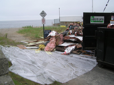
Demolition: Asbestos hazmat containment in floodplain, critical wildlife habitats, a reservoir for sand supply,
a buffer for coastal flooding and erosion intact.
|
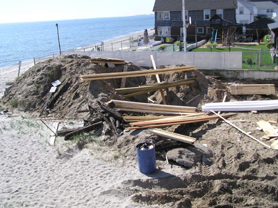
Floodplain reconstruction.
|
|
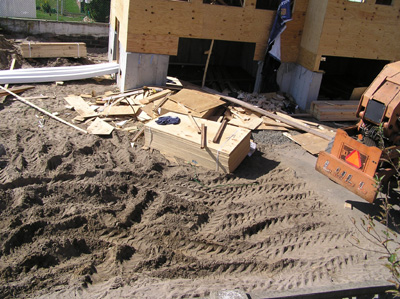
First floor construction (in flood plain) of 4 story residential structure.
|
Residents along the shoreline in Milford, Connecticut
are striving to address challenges associated with (1) severe beach erosion
and (2) the potential need for the formation of a coastal planning agency to oversee development
of the shoreline.
Focus issues include coastal policies and definitions outlined by the Department
of Environmental Protection: Office of Long Island Sound Programs (Reference Guide to Coastal Policies and Definitions) and include:
- Degrading visual quality
through significant alteration of the natural features of vistas and viewpoints.
CGS Section 22a-93(15)(F).
- "Beaches
and Dunes" means beach systems including barrier beach spits and tombolos,
barrier beaches, pocket beaches, land contact beaches and related dunes and
sandflats. CGS Section 22a-93(7)(C).
- To preserve the dynamic form and integrity of natural beach systems
in order to provide critical wildlife habitats, a reservoir for sand supply,
a buffer for coastal flooding and erosion, and valuable recreational opportunities.
CGS Section 22a-92(b)(2)(C).
- To
insure that coastal uses are compatible with the capabilities of the system
and do not unreasonably interfere with natural processes of erosion and sedimentation.
CGS Section 22a-92(b)(2)(C).
- To encourage the restoration and enhancement of disturbed or modified beach systems. CGS Section 22a-92(b)(2)(C).
- To require as a condition in permitting new coastal structures, including
but not limited to, groins, jetties or breakwaters, that access to, or along,
the public beach below mean high water must not be unreasonably impaired
by such structures and to encourage the removal of illegal structures below
mean high water which unreasonably obstruct passage along the public beach. CGS Section 22a-92(c)(1)(K).
In the context of coastal property development, efforts focused on "Reducing Flood Losses Through the International Codes" (FEMA: Department of Homeland Security) include:
- When an applicant proposes
activities that involve alteration of a watercourse, IBC Appendix G, Section
G103 specifies that the building official shall require the applicant to
notify FEMA, the state, and adjacent communities. -- Chapter 4, Section 5.
- Communities
are required to prohibit any floodway encroachments, including fills, new
construction, and substantial improvements, if they would cause flood levels
to increase more than a designated height. The designated height limit on
the allowable increase is found in the floodway tables of a community’s Flood
Insurance Study. If a community decides to permit a floodway proposal that
could cause an increase in the base flood elevation (BFE), a Conditional
Letter of Map Revision (CLOMR) and floodway map revision must be reviewed
and issued by FEMA. Preliminary permit approvals should be conditioned on
the applicant obtaining the CLOMR. -- Chapter 4, Section 6.
- Certain
ground and building elevations are to be surveyed and certified so that building
officials can determine the elevation of the lowest floor. The lowest floor
elevation is the most significant element in determining that floodplain
construction is compliant. -- Chapter 4, Section 8.
- FEMA’s Elevation Certificate (FEMA Form 81-31): Surveyor/Engineer.
A registered professional who is licensed to perform elevation surveys is
required to complete, sign, and affix a professional seal to the documentation
of elevations. The documentation must be dated to document when the elevations
were surveyed because continuing construction or future modifications could alter
and/or outdate the information shown. The registered professional is responsible
for obtaining and certifying accurate elevations of key ground and building
elevations. -- Chapter 4, Section 8.
- The
2006 and 2003 IBC. Section 112 creates a board of appeals to hear and decide
appeals of orders, decisions, or determinations made by the building official.
Specific requirements, considerations, and conditions for issuing variance
from floodplain management requirements can be found in IBC Appendix G, Section
G105. -- Chapter 4, Section 11.
- If a municipality meets the requirements of the NFIP through the International
Codes only, then they must Adopt the IBC and IBC Appendix G (and by reference the IRC, IEBC, and other I-Codes). -- Figure 6-1.
- Appendix
G103.5 Floodway encroachment. Prior to issuing a permit for any floodway
encroachment, including fill, new construction, substantial improvements
and other development or land disturbing activity, the building official
shall require submission of a certification, along with supporting technical
data, that demonstrates that such development will not cause any increase
of the level of the base flood. -- Appendix: B-21.
- Appendix G103.7 Alterations in coastal areas. Prior to issuing a permit
for any alteration of sand dunes and mangrove stands in flood hazard areas
subject to high velocity wave action, the building official shall require
submission of an engineering analysis which demonstrates that the proposed
alteration will not increase the potential for flood damage. -- Appendix: B-25.
The key to improved public management of Connecticut's coastal area is
coordination at all levels of government and consideration by municipalities
of the impact of development on both coastal resources and future water-dependent
development opportunities when preparing plans and regulations and reviewing
municipal and private development proposals. -- Connecticut Coastal Management Act: Sec. 22a-91 (6)
Related:
|
|